This Radar Image of Alberto Looks like a Hurricane Set to Hit Michigan
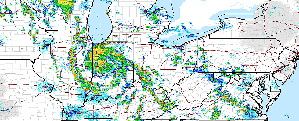
Look out Michigan and batten down the hatches - at least that's what this radar image makes you think. That's the remnants of Alberto, the first named storm of the 2018 Atlantic hurricane season over Indiana and churning for Michigan.
The first 'bands' of Albert have just met Lake Michigan and the southern state line as of this 4PM May 30 image.
The remnants of that storm could bring up to 2 inches of rain to much of Lower Michigan south of Ludington and Clare, west of Jackson
Showers and thunderstorms are expected to develop this afternoon and will become more numerous by this evening. Showers and storms will produce heavy downpours and occasional cloud to ground lightning strikes. Rainfall totals exceeding 2 inches are likely over a portion of the area, which could lead to urban and small stream flooding,
and also some road closures this evening into tonight. Use caution as the dangers of flooded roads are especially difficult to recognize at night. If you encounter a flooded road, turn around, and find another way.
The National Hurricane Center, which is still tracking Alberto as it moves into the Great Lakes forecasts,
RAINFALL: Additional rainfall of 2 to 4 inches, with isolated higher amounts, will be possible northward along the Illinois/Indiana border into the Lower Peninsula of
Michigan. Flash flooding and rapid water rises on creeks and streams will remain a possibility across these areas.WIND: A few wind gusts may approach tropical-storm force (34 knots or 39 mph) across western and central Indiana today.
BONUS VIDEOS - Michigan Oddities
[h/t Michigan Weather]
More From Kalamazoo's Country


![Punk Rockers NOFX Joke About Las Vegas Shooting Victims: ‘At Least They Were Country Fans’ [Watch]](http://townsquare.media/site/204/files/2018/05/nofx.jpg?w=980&q=75)